

Introduction: A New Era of Discovery at the Giza Plateau
The Giza Plateau, home to the iconic pyramids of Egypt, has long captivated the imagination of archaeologists, historians, and enthusiasts alike. For centuries, these ancient structures have stood as testaments to the ingenuity of the ancient Egyptians, but recent advancements in technology are shedding new light on what lies beneath the surface. One of the most exciting developments in this field is the Khafre Pyramid Project's creation of a detailed 3D model of the entire Giza Plateau, revealing potential underground structures that have remained hidden for millennia.
This groundbreaking work, presented by Professor Filippo Biondi, utilizes cutting-edge Synthetic Aperture Radar (SAR) Doppler Tomography technology to map the internal and external features of the plateau with unprecedented precision. The 3D model, first unveiled to the public, offers a glimpse into a complex network of subterranean chambers and passages, challenging our understanding of how these monuments were constructed and used. This article delves into the significance of this discovery, the technology behind it, and what it might mean for the future of archaeological exploration.
The Khafre Pyramid Project: A Brief Overview
The Khafre Pyramid Project is a multidisciplinary initiative aimed at uncovering the secrets of the Giza Plateau using modern scientific methods. Named after the Pharaoh Khafre, who is believed to have commissioned the second-largest pyramid at Giza, the project brings together experts in archaeology, geophysics, and data visualization to explore the plateau's hidden depths. Professor Filippo Biondi, a key figure in the project, has led efforts to apply SAR-Doppler Tomography—a technique that combines radar imaging with Doppler frequency analysis—to penetrate the ground and create detailed 3D reconstructions.
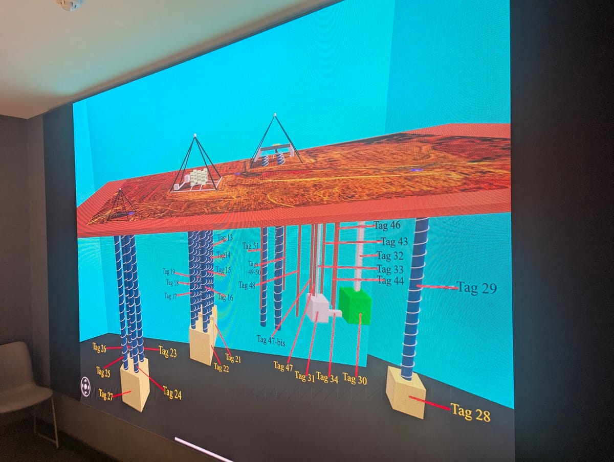
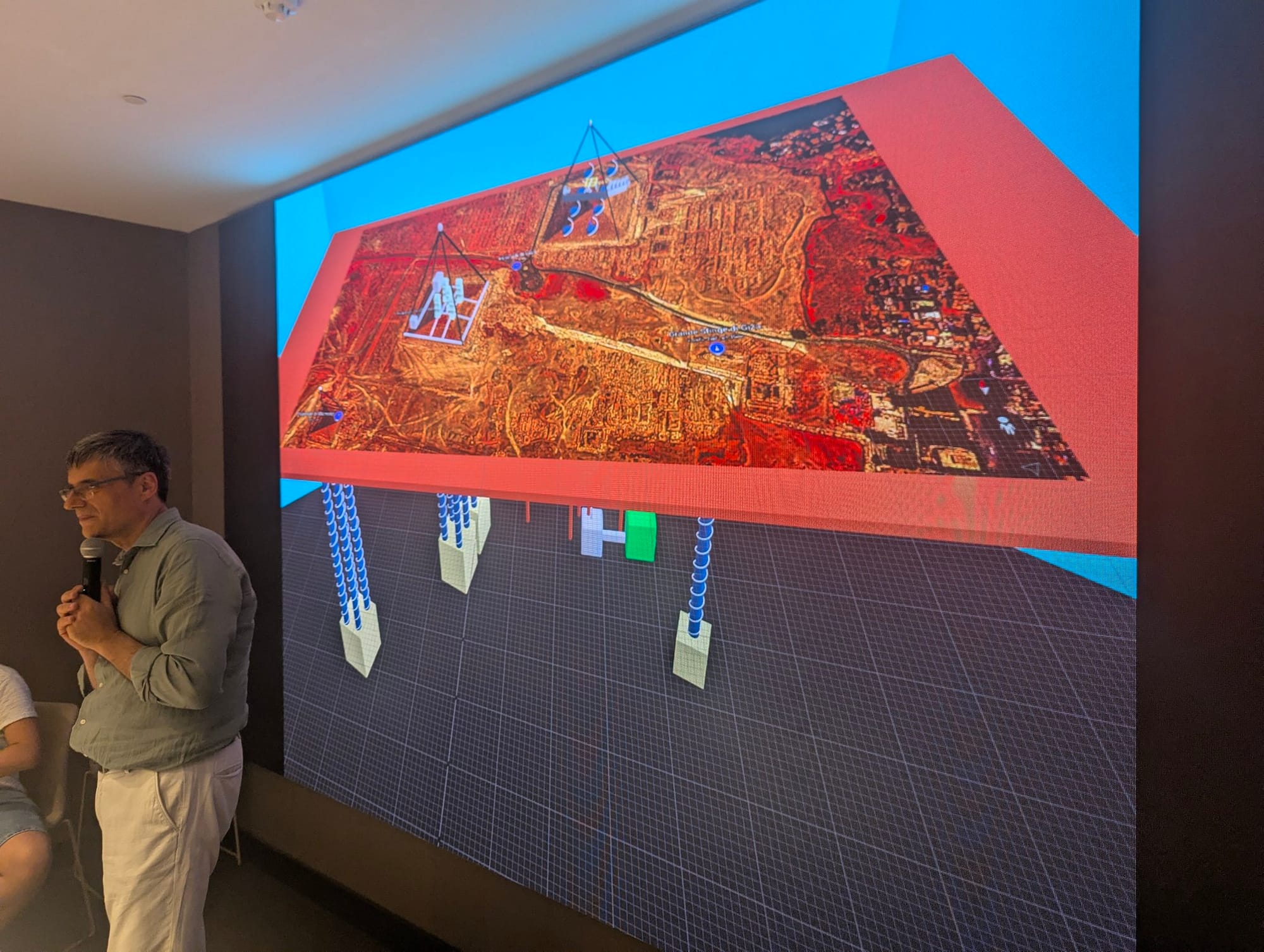
The project's recent presentation, which included nearly two hours of data, showcased a stunning 3D model of the Giza Plateau. This model not only depicts the visible pyramids but also suggests the presence of extensive underground structures, marked with tags such as Tag 29, Tag 33, and Tag 46. These tags correspond to specific points of interest where anomalies in the data indicate possible chambers, tunnels, or other features. The model's release marks a significant milestone in the study of Giza, offering a new tool for researchers to hypothesize about the plateau's past.
The Technology Behind the 3D Model: SAR-Doppler Tomography
To understand the significance of the Khafre Pyramid Project's 3D model, it’s essential to explore the technology that made it possible. SAR-Doppler Tomography is a sophisticated imaging technique that builds on the principles of Synthetic Aperture Radar (SAR). Traditionally, SAR is used to create high-resolution images of the Earth's surface by sending microwave signals and analyzing the echoes that bounce back. However, its ability to penetrate solid objects has been limited, making it challenging to study internal structures.
The innovation of Doppler Tomography lies in its use of Doppler frequency shifts—changes in the frequency of the returned signals caused by the motion of objects or vibrations within the target area. By analyzing these shifts, researchers can detect subtle movements or anomalies beneath the surface, such as those caused by hidden chambers or structural weaknesses. When applied to the Giza Plateau, this method has revealed details that traditional excavation or ground-penetrating radar could not.
The data for the 3D model was collected using the Italian COSMO-SkyMed satellite system, which provides high-resolution SAR images. These images were processed to estimate vibrational profiles and Doppler centroid anomalies, allowing the team to reconstruct the plateau's subsurface in three dimensions. The result is a visually striking model that highlights both the known pyramids and the potential underground network, offering a new perspective on one of the world's most studied archaeological sites.
Decoding the 3D Model: What the Tags Reveal
The 3D model presented by the Khafre Pyramid Project is annotated with numerous tags, each representing a point of interest identified through the SAR-Doppler analysis. These tags, ranging from Tag 17 to Tag 46, are strategically placed to indicate areas where the data suggests the presence of underground features. Let’s break down some of the key elements visible in the model:
- Surface Representation: The top layer of the model depicts the Giza Plateau as it appears today, with the pyramids of Khufu, Khafre, and Menkaure prominently featured. The reddish-brown texture mimics the desert landscape, providing a familiar reference point.
- Vertical Columns: Extending downward from the surface are a series of blue columns, each labeled with a tag number. These columns likely represent the depth at which anomalies were detected, suggesting vertical shafts or passages.
- Subsurface Structures: At various depths, the model includes green and white blocks, such as those near Tag 29 and Tag 44. These could indicate chambers or cavities, with the green block possibly representing a significant find due to its distinct color coding.
- Connections and Pathways: Red lines connecting the tags suggest potential tunnels or corridors linking the underground features, hinting at a complex network beneath the plateau.
The placement of these tags is not arbitrary; it reflects the data collected over months of satellite imaging and analysis. For instance, Tag 29 and Tag 33, located toward the center of the model, may correspond to areas near the Great Pyramid of Khufu, where previous studies have hinted at undiscovered chambers. Similarly, Tag 46, positioned toward the edge, could relate to the Menkaure Pyramid or surrounding structures. While the exact nature of these features remains speculative until further investigation, the model provides a roadmap for future exploration.
Historical Context: What Lies Beneath Giza?
The possibility of extensive underground structures at Giza is not entirely new. Ancient Egyptian texts and later accounts by Greek historians, such as Herodotus, have long suggested that the pyramids were part of a larger complex that included subterranean elements. Herodotus, writing in the 5th century BCE, described the Great Pyramid as having underground chambers connected by passages, though he provided few details. Archaeological evidence, such as the discovery of the Osiris Shaft—a deep shaft near the Great Pyramid containing water and artifacts—has also supported the idea of a hidden network.
The Khafre Pyramid Project's 3D model builds on this historical context by providing a visual representation of what might lie beneath. The presence of vertical columns and interconnected chambers could indicate a system designed for practical purposes, such as water management or burial preparation, or for symbolic reasons, such as a subterranean temple. Some researchers speculate that these structures might be linked to the ancient Egyptians' advanced knowledge of astronomy and engineering, potentially serving as part of a larger ritual landscape.
One intriguing theory is that the underground network was intended to align with celestial events, a common practice in ancient Egyptian architecture. The pyramids themselves are oriented with remarkable precision to the cardinal directions, and the subsurface features could extend this alignment underground. The 3D model's depiction of a structured layout supports this hypothesis, though further research is needed to confirm it.
Implications for Archaeology and Beyond
The unveiling of the Khafre Pyramid Project's 3D model has far-reaching implications for the field of archaeology. Traditionally, exploring underground structures has relied on invasive methods like excavation, which can be time-consuming and risk damaging delicate artifacts. The use of non-invasive technologies like SAR-Doppler Tomography offers a safer and more efficient alternative, allowing researchers to map entire sites before deciding where to dig.
For the Giza Plateau, this approach could accelerate the discovery of new chambers and artifacts, potentially rewriting our understanding of ancient Egyptian civilization. The model’s suggestion of a network beneath the pyramids raises questions about their construction techniques, the labor involved, and the cultural significance of the site. It also opens the door to interdisciplinary collaboration, bringing together archaeologists, geophysicists, and historians to interpret the data.
Beyond archaeology, the technology used in this project has applications in other fields. SAR-Doppler Tomography could be employed to study other historical sites, monitor natural disasters, or assess the stability of modern infrastructure. The success of the Khafre Pyramid Project demonstrates the power of combining satellite technology with advanced data processing, setting a precedent for future explorations.
Challenges and Limitations
Despite its promise, the 3D model is not without challenges and limitations. The interpretation of SAR-Doppler data relies heavily on the accuracy of the satellite imagery and the algorithms used to process it. Small errors in data collection or analysis could lead to misidentifications, with natural geological features mistaken for man-made structures. The green and white blocks, for example, might represent cavities caused by erosion rather than constructed chambers.
Another limitation is the resolution of the model. While the 3D reconstruction provides a broad overview, it lacks the fine detail needed to confirm the exact nature of the underground features. Ground-truthing—verifying the data through physical exploration—will be essential to validate the findings. This process could take years, given the logistical challenges of excavating at a site as sensitive and heavily regulated as Giza.
Additionally, the model’s reliance on vibrational analysis means it may miss features that do not produce detectable movements. Solid, stable structures might remain invisible unless they are disturbed by external forces. These limitations highlight the need for a multi-method approach, combining SAR-Doppler Tomography with other techniques like ground-penetrating radar or muon detection, which has previously been used to identify hidden chambers in the Great Pyramid.

The Road Ahead: Future Exploration and Research
The release of the 3D model is just the beginning of a new chapter in Giza’s exploration. Professor Filippo Biondi and the Khafre Pyramid Project team are committed to further analyzing the data and conducting follow-up studies. One of the next steps is to conduct targeted excavations or non-invasive surveys at the tagged locations to confirm the presence of underground structures. This could involve collaboration with Egyptian authorities and international archaeological organizations to ensure the work is conducted responsibly.
The project also plans to release a full 1-hour-and-30-minute technical presentation, recorded in 4K quality, to provide a detailed explanation of the methodology and findings. This presentation will likely include additional scans and data, offering a deeper dive into the model’s creation and the implications of the discoveries. Interviews with Biondi and other team members are also in the works, providing an opportunity to hear firsthand about the challenges and excitement of the project.
For the public, the 3D model opens up new possibilities for virtual exploration. As technology advances, interactive versions of the model could be made available online, allowing enthusiasts to navigate the Giza Plateau and explore its hidden depths from their homes. This democratization of knowledge could inspire a new generation of researchers and spark renewed interest in ancient history.
Cultural and Scientific Significance
The Khafre Pyramid Project’s work carries profound cultural and scientific significance. For Egypt, the Giza Plateau is a national treasure and a symbol of its rich heritage. Any new discoveries could enhance the country’s cultural narrative and boost tourism, an important economic driver. The 3D model also reinforces Egypt’s role as a leader in archaeological innovation, showcasing how modern technology can complement traditional methods.
Scientifically, the project contributes to our understanding of ancient engineering and the limits of human achievement. The possibility of a subterranean network suggests that the ancient Egyptians possessed sophisticated planning and construction skills, challenging previous assumptions about their capabilities. It also raises questions about the purpose of these structures—were they functional, symbolic, or a combination of both?
The discovery could also have implications for the study of other ancient civilizations. If the Giza Plateau contains a complex underground system, similar features might exist at other pyramid sites, such as those in Sudan or Mexico. Comparative studies could reveal commonalities in ancient architecture and provide insights into global cultural exchanges.
Public Reaction and Speculation
The unveiling of the 3D model has generated a wave of excitement and speculation among the public. Enthusiasts and amateur archaeologists have taken to online forums to discuss the potential meanings of the tagged features, with some suggesting connections to lost civilizations or extraterrestrial influences. While these ideas are intriguing, they remain speculative and lack scientific support at this stage.
More grounded reactions have focused on the model’s potential to uncover new artifacts or confirm historical accounts. The image of the green block near Tag 29, for instance, has sparked debates about whether it could be a burial chamber or a storage area for ceremonial goods. The red lines connecting the tags have also fueled theories about a hidden transportation system or ritual pathway.
This public engagement highlights the enduring fascination with Giza and the power of visual tools like the 3D model to capture the imagination. As more data becomes available, these discussions will likely evolve, blending scientific inquiry with cultural curiosity.
Conclusion: A Window into the Past
The Khafre Pyramid Project’s 3D model of the Giza Plateau represents a monumental step forward in our exploration of one of history’s greatest mysteries. By harnessing the power of SAR-Doppler Tomography, the project has provided a detailed glimpse into the plateau’s subsurface, revealing a potential network of underground structures that could redefine our understanding of ancient Egypt. From the tagged columns and chambers to the red lines suggesting connections, the model offers a tantalizing preview of what lies beneath.
As the project moves forward with further research and exploration, the world watches with bated breath. The combination of cutting-edge technology and historical intrigue promises to unlock new secrets about the pyramids and their builders. Whether these discoveries confirm long-held theories or introduce entirely new perspectives, they underscore the importance of continued investigation into our shared human heritage.
For now, the 3D model stands as a testament to human curiosity and innovation, bridging the gap between the ancient past and the modern era. As we await the next chapter in this unfolding story, one thing is clear: the Giza Plateau still has much to teach us, and the Khafre Pyramid Project is leading the way into its hidden depths.